


INTRODUCTION
This mini-site was dedicated to studying key issues of Sarawak in preparation for the upcoming state election of 2020/2021. Please respect this principle, as this mini-site is for academic, NGO, personal, and noncommercial purposes. Citations are to follow what is written in each section. Each user is to exercise discretion when referring to the data, and we are not responsible for any errors and omissions.
SARAWAK: OVERVIEW OF 2021 ELECTIONS
UPDATED ON 21/12/2021
You can find any of the state constituencies in the interactive map below to learn who your elected representative is, his or her political affiliation, and other election-related data.
For a larger view (highly recommended), click here
For data download (please use after doing independent checks), click here
We are not responsible for any errors and omissions arising from the data file, and are not responsible for any misuse of the derivatives.
The map application and data file were compiled by the Tindak Malaysia Election Analysis Unit (2021).
For Citation (for interactive map visualization and data file): As per our GitHub link for Election Results and Composition
SECTIONS
- Sarawak: Electoral, Administrative and Local Authority Boundaries
- Sarawak: Electorate & Total Population
- Sarawak: DUN Composition & Political Scene
- Sarawak: Deforestation Issue
- Sarawak: Water Accessibility
- Sarawak: Specific Constituency Stories (Updated)
- (Future Topics)
Sarawak: Electoral, Administrative and Local Authority Boundaries
The link to the Sarawak State Electoral and Administration Map (Zone Lookup Option): https://shorturl.at/crr1J
The link to the Sarawak State Electoral and Administration Map (Layer Style Option): https://arcg.is/1GaiHr1
Sources for the above map links: Election Commission (SPR), Sarawak Ministry of Public Health, Housing and Local Government (MPHLG), Gazette Plan (Sarawak Land and Survey Department), Kuching North City Hall, Kuching South City Council, and Padawan Municipal Council.
Both map applications are to be used for all non-commercial purposes. TindakMalaysia Network Services PLT. Users must exercise discretion when interpreting electoral boundaries, certain local authority areas, and districts. TindakMalaysia Network Services PLT is not responsible for errors and omissions arising from the application and subsequent usage. There is minor issue with visual display of Majlis Daerah Luar Bandar Sibu as it encapsulates Majlis Perbandaran Sibu
Sarawak has 12 Divisions (Bahagian); under each Division, there are two or more districts (Daerah). Under the districts, there are subdistricts (Daerah Kecil)
Sarawak has 29 Local Authority Areas (Pihak Berkuasa Tempatan – PBT) as of 2025. Sarawak is home to one of the three City Halls in Malaysia – Dewan Bandaraya Kuching Utara. In Sarawak, like other parts of Malaysia, there are different types of Local Authorities, and they are:
-
- City Hall/City Council (Dewan Bandaraya/ Majlis Bandaraya) – examples: Kuching, Miri
- Municipal Council (Majlis Perbandaran) – examples: Padawan
- District Council (Majlis Daerah) – example: Kapit
- Special Areas (i.e. Lembaga Kemajuan) – example: Bintulu
Each type of Local Authority Area comes with different responsibilities and expectations. You can find more here – https://jkt.kpkt.gov.my/node/36
Sarawak has 82 State Legislative Assembly Seats/ State Constituencies (Kawasan Pilihan Raya Dewan Undangan Negeri (DUN)) and 31 parliamentary seats. The boundaries of the 82 state constituencies have been enforced since 2015, and Sarawak was due for redelineation since 2023. However, with the addition of 17 state constituencies in July 2025, there will be an upcoming redelineation.
A subdistrict is a subset of a district. A district is a subset of a Division. However, there is no absolute correspondence between the boundaries of land administration (districts) with local authority areas and electoral boundaries. A state constituency could span multiple districts or be a subset of a Local Authority Area. A local authority area can span multiple districts or be confined to a small section of a district. Under a Local Authority Area, there are councillor wards.
Archive
We, at Tindak Malaysia, have developed an interactive map application (below and archived) for you to identify your District, Sub-District, Division, Local Authority Area, State Constituency, and Parliamentary Constituency. The map was built through a joint effort between Michael Leow and Danesh Prakash Chacko (2020). The map was subsequently updated through a joint effort between SM Sabri and Danesh Prakash Chacko (2023). The map has undergone two rounds of updates by Danesh Prakash Chacko in early 2024 to reflect the latest district boundaries and formation of Majlis Daerah Gedong (2024). The old map link was archived in light of significant revisions in 2025
Corrections were made to the locations of Pantu and Lingga Districts and the shape of Majlis Perbandaran Padawan on 16th March 2024. A new correction was made for the District of Kapit on 2nd November 2024.
Instructions
- Click on any part of the map to query the name of the state constituency (DUN), local council area, district, and divisional boundaries.
- Click on the Layers to turn on and turn off the layers before querying.
For Citation (for the old link): Laporan Kajian Semula Persempadanan mengenai Syor-Syor yang dicadangkan bagi Bahagian – Bahagian Pilihan raya Persekutuan dan Negeri di dalam Negeri Sarawak Kali Keenam 2015 (EC), Division Websites, Department of Statistics Malaysia, International Steering Committee for Global Mapping Malaysia. (Jabatan Ukur dan Pemetaan), Local Council Website, Unit Komunikasi Awam Sarawak, Sarawak State Attorney-General’s Chambers, compiled by Tindak Malaysia (2020) and updated in 2023 and 2024.
The link to the Sarawak State Electoral and Administration Map: https://shorturl.at/Y8WnT (Archived)
Sarawak: Electorate & Total Population
Electorate Scene
As Sarawak gears up for the next state election, our research concluded that Sarawak has been experiencing a slower growth in electorate size, with some constituencies experiencing minor depopulation. Having said that, being an elector (the term voter is applicable for polling day) is optional in Malaysia, and the elector has been given the freedom to update the Election Commission of his or her new address. This creates an unquantifiable amount of mismatches between the actual electorate who reside in Sarawak and the electorate who, on paper, reside in Sarawak.

Irrespective of the mismatches, the urgency for Sarawakians to register soon is the highlight of the map application. Click the map application here to learn more about Sarawak’s evolving State Constituency Electorate Population since 2015. Follow the Instructions within the application (which is shown on the left-hand side).
The map application was built by the Tindak Malaysia Election Analysis Unit (2020).
For Citation: Attorney General Chambers, Senarai Harga Daftar Pemilih Induk Tahun 2019 (EC), Laporan Keputusan Akhir Dewan Undangan Negeri bagi Negeri Sarawak Tahun 2016 (EC), Laporan Kajian Semula Persempadanan mengenai Syor-Syor yang dicadangkan bagi Bahagian – Bahagian Pilihan raya Persekutuan dan Negeri di dalam Negeri Sarawak Kali Keenam 2015 (EC), PKR, Compiled by Tindak Malaysia Election Analysis Unit.

Population Scene
Sarawak’s population has grown 1.7 times since 1991 and currently has a population estimate of 2,828,900 (2018) according to the Department of Statistics (DOSM). In the 2018 estimate, 55% of the Sarawakian population resided in the districts of Kuching, Bintulu, Miri, and Sibu (home to the four main cities that share the same names as their parent districts). This is an increase of 7% in concentration since 1991.
The top three districts that experienced a multiplication of population increase were:
- Samarahan – Grown by 3 times since 1991
- Bintulu – Grown by 2.5 times since 1991
- Miri – Grown by 2.2 times since 1991
While the population has grown strongly in the more urbanized districts, Sarawak has been experiencing a severe malapportionment among state constituencies, which disadvantages urbanites. The map below shows the implications of the redelineation (then) proposals of 2015, which grossly reduced voter value for Sarawakians who reside in urban areas. In 2018, approximately 58% of the Sarawakians resided in urban areas (refer here).

The map below shows the evolution of population growth in the districts of Sarawak since 1991.
Instructions
- Click the map below for a larger view
- You are taken to the full view of the map. Click on the image for a larger view
- Click again to minimize the view
- Click the back button to return to the main menu
- Please read the statement below the population map on the Sarawak Election Site to understand the reasons for missing data
The map was compiled by the Tindak Malaysia Election Analysis Unit (2020)
For Citation: Department of Statistics of Malaysia (DOSM), Data.Gov.my, International Steering Committee for Global Mapping (Malaysia, Jabatan Ukur dan Pemetaan), Majlis Daerah Betong, Majlis Daerah Sibuti, Majlis Perbandaran Padawan, Unit Komunikasi Awam Sarawak, compiled by Tindak Malaysia (2020)
Any modification (parts or whole) of the map below for non-Tindak purposes requires written permission, which can be directed via info@tindakmalaysia.com
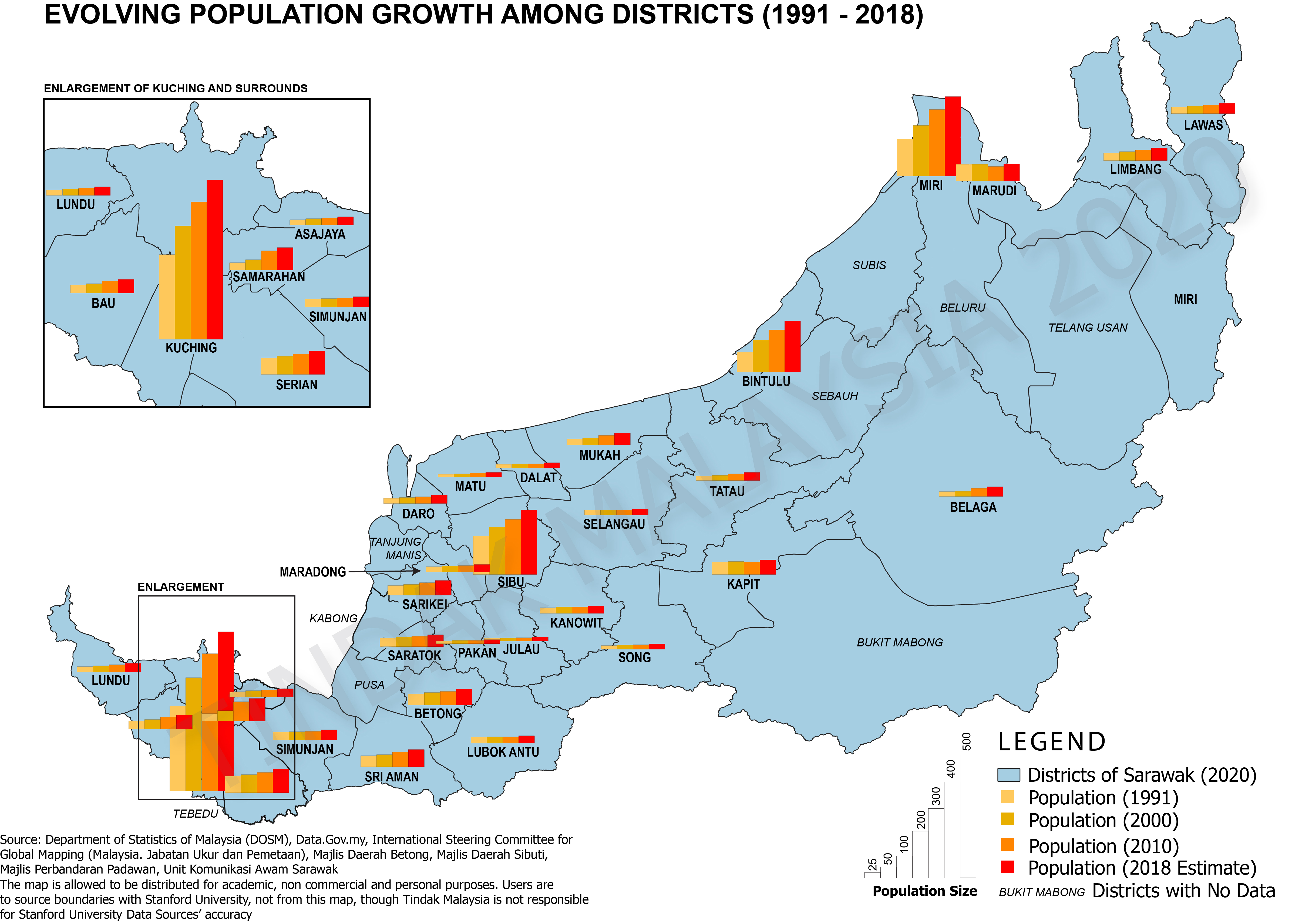
* Tebedu was once part of Serian District, Pusa was part of Betong District, Kabong was part of Saratok District, Tanjung Manis was part of Daro District, Sebauh was part of Bintulu District, Bukit Mabong was part of Kapit District, Beluru and Telang Usan Districts were part of Marudi District
Ethnic Composition Scene
UPDATED ON 21/12/2021 WITH CORRECTIONS FOR 2021 ETHNICITY DATA
Sarawak is an ethnically diverse state where no particular ethnic majority dominates the state outright (this has influenced the political attitudes of the state government over the years). In 2017, the Iban community constituted 29% of the total population (not referring to the electorate), Malays (23%), Chinese (22%), Bidayuh (8%), Melanau (5%), Other Indigenous Groups (6%), Indians and Others (1%) and Non-Citizens (6%).
In terms of Electorate Breakdown of Seats, in 2016 there were 28 Malay and Melanau Majority Seats (34% of the total 82 seats), 22 Iban Majority Seats (27% of total seats), 15 Chinese Majority Seats (18% of total seats), 6 Bidayuh Majority Seats (7% of total seats), 4 Orang Ulu Majority Seats (5% of total seats) and 7 Mixed Seats (8% of total seats). Malay and Melanau communities are overrepresented communities in Sarawak DUN Composition while Iban Community is underrepresented on the other hand. Bidayuh and Chinese communities are slightly underrepresented in the Sarawak DUN.
For the 2016 Data, please visit Tindak Malaysia’s GitHub link.
ABOVE PARAGRAPH WAS UPDATED ON 12/12/2024 WITH CORRECTIONS FOR 2016 ETHNIC MAJORITY CONSTITUENCIES
In the link below, the simple interactive map shows the ethnic majorities for each DUN for the year 2016, the year when Sarawak conducted its 11th State Elections.
Click here for a larger view.
Hover over any of the state constituencies in the interactive map below to learn about the ethnic composition of the Sarawak Electorate Scene.
The map was compiled by the Tindak Malaysia Election Analysis Unit (2020) and updated in 2021
For Citation: New Straits Times (11th Sarawak Election: Full Official Results), SPR Malaysia, Tindak Malaysia (2020)
In terms of Electorate Breakdown of Seats, in 2021 there are 28 Malay and Melanau Majority Seats (34% of the total 82 seats), 22 Iban Majority Seats (27% of total seats), 16 Chinese Majority Seats (20% of total seats), 8 Bidayuh Majority Seats (10% of total seats), 5 Orang Ulu Majority Seats (6% of total seats) and 3 Mixed Seats (4% of total seats). Malay and Melanau communities are an overrepresented community in Sarawak DUN Composition while Iban Community is underrepresented on the other hand. Bidayuh and Chinese communities are slightly underrepresented in the Sarawak DUN.
Seats that potentially may have experienced ethnic majority reclassification from 2016 to 2021 are:
- N.23 Bukit Semuja (Mixed to Bidayuh)
- N.75 Senadin (Mixed to Chinese)
*Serembu 2016 data was corrected to Bidayuh majority (corrected to 12/12/2024). New Straits Times data for Serembu was deemed erroneous
In the link below, the simple interactive map shows the ethnic majorities for each DUN for the year 2021, the year when Sarawak conducted its 12th State Elections.
Click here for a larger view.
Hover over any of the state constituencies in the interactive map below to learn about the ethnic composition of the Sarawak Electorate Scene.
For Citation: New Straits Times, The STAR, SPR Malaysia, Tindak Malaysia (2021)
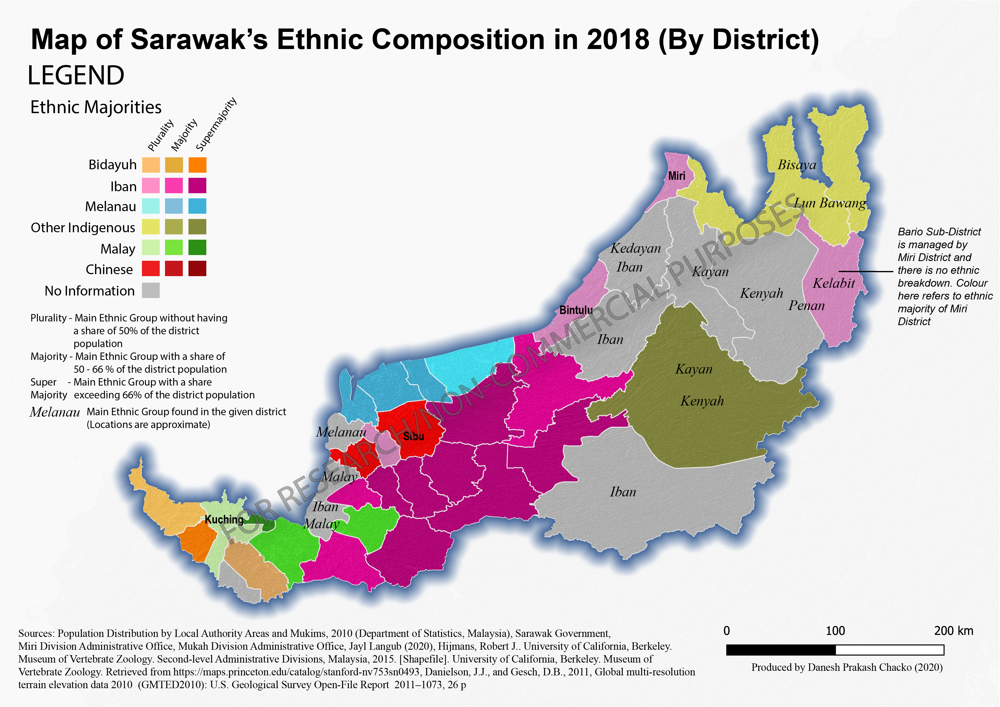
The next map highlights ethnic distribution among administrative districts using the Department of Statistics, Malaysia, 2018 projections. Proportions are calculated using the Total Population (inclusive of non-Malaysians).
The map was compiled by Danesh Prakash Chacko.
For Citation: Follow what is listed in the map in its fullest form.
SARAWAK: DUN COMPOSITION & POLITICAL SCENE
Sarawak DUN Scene from 2006 – 2016
From Tindak Malaysia’s analysis of three election cycles at the DUN level and recorded incidents of electoral abuses, the following seats should be closely monitored:
- Tasik Biru
- Kota Sentosa
- Batu Kitang
- Batu Kawah
- Repok
- Dudong
- Bawang Assan
- Pelawan
- Piasau
- Pujut
- Senadin
- Telang Usan
- Ba’kelalan
The map below shows a general overview of the evolving electoral scene of Sarawak from 2006 to 2016. Over the years, the chief ministers of Sarawak have been changed, new political alliances were born, the opposition parties such as DAP and PKR experienced some inroads (and setbacks too), and the 2015 redelineation exercise coincided with the addition of 11 new state constituencies.
Instructions
- Click the map below for a larger view
- You are taken to a full view of the map. Click on the image for a larger view
- Click again to minimize the view
- Click the back button to return to the main menu
The map product is jointly built by Danesh Prakash Chacko and Keng Hooi Teoh.
For Citation: EC Malaysia, Wikipedia, compiled by Tindak Malaysia (2020)
For historical Election Results and the Composition of Sarawak elections from 2006 to 2016, please visit our GitHub link.
Any modification (parts or whole) of the map below for non-Tindak purposes requires written permission, which can be directed via info@tindakmalaysia.com

WORK IN PROGRESS
SARAWAK: DEFORESTATION ISSUE
WORK IN PROGRESS
While the majority of Sarawak’s area is under forest cover (2018), industrial plantations (i.e., oil palm) have been the principal drivers of deforestation in Sarawak for the past four decades (refer here). In 2018, Sarawak had 6.3 million hectares of forest area, which is slightly over 50% of the state. From 2000 to 2018, Sarawak lost nearly 1.8 million hectares of forest area, where nearly 50% of the loss was attributed to oil palm plantation expansion. The bulk of the forest loss largely occurred before the year 2010. Some of the consequences of deforestation and logging are an increasing number of flood events, loss of access to traditional food and clean water, and destruction of sources of income (refer here)
Having said that, forest losses from 2015 have substantially reduced, and more so, the growth of industrial oil palm and pulpwood plantations has slowed down. One of the primary factors contributing to the slowing of oil palm plantation growth is due to the decline of crude palm oil prices (refer here). Moreover, one must also attribute the efforts of the government, private sector (i.e., banks), and civil society to keeping a lid on the growth of these plantations.
This section briefly looks at key figures of the Sarawak Deforestation Scene.
Click on the Brief Story of Sarawak’s Deforestation Scene link here to obtain a quick overview of the issue. This application is built by Danesh Prakash Chacko with the advice of Keng Hooi Teoh (2020)
Instructions
- Once you click the link, it will open in a separate tab
- On the topmost part of the application (Key Facts), you will see three sections – Opening Page, Overview of Land Use and Deforestation, and Key Facts. Click on any of these options to view dedicated dashboards
- For the dedicated dashboard section, hover over the area, bar, and line charts to see the values at different intervals of time
For Citation for Key Facts: Center for International Forestry Research (CIFOR), https://atlas.cifor.org/, EC Malaysia, compiled by Tindak Malaysia (2020)

The image above shows the content of the application when you open the link
SARAWAK: WATER ACCESSIBILITY
WORK IN PROGRESS
One of the key features that appear in Sarawak state elections is the distribution of water tanks in rural areas. This begs the question of why water tanks are still being distributed to rural areas as opposed to seriously investing in a regular and stable water supply. The 2020 National Budget under the PH government allocated RM470 million for rural water supply connectivity for Sabah and Sarawak (refer here). However, the Sarawakian state government believes this allocation is below the expected expense (of RM 3 billion) to enable a full rural water supply for Sarawak. Sarawak’s government estimated that such an allocation would only increase the coverage of water supply by a minuscule number (0.3%). To delve further into this issue, this section is dedicated to highlighting to all readers how access to water across Sarawak has evolved.
Quick Facts
- Access to piped water in a house has increased from 80.8% (2012) to 86.4% (2019) of households in Sarawak
- Access to piped water in a house for urban areas has been consistently around 98 – 99.4% (2012 – 2019) of households in Sarawak
- Access to piped water in a house for rural areas has grown from 57.4% (2012) to 69.8 % (2019) of households in Sarawak
- Around 42% of Sarawak’s population resided in rural areas in 2018
- The top State Constituencies receiving water tanks in 2016 were Opar (1500) and Tanjung Datu (1500). Both are largely located in Lundu District, where 45.2% of the households received piped water access at home (2016)
The map below shows a quick comparison of the growth of access to piped water for households in Sarawak by administrative districts
Instructions
- Click the map below for a larger view
- You are taken to a full view of the map. Click on the image for a larger view
- Click again to minimize the view
- Click the back button to return to the main menu
Map compiled by Tindak Malaysia Election Analysis Unit (2020)
For Citation: Department of Statistics of Malaysia, International Steering Committee for Global Mapping (Malaysia. Jabatan Ukur dan Pemetaan), Jabatan Ukur dan Pemetaan, Tindak Malaysia (2020)
Any modification (parts or whole) of the map below for non-Tindak purposes requires written permission, which can be directed via info@tindakmalaysia.com

SARAWAK: CONSTITUENCY-SPECIFIC STORIES
This section is dedicated to specific stories and analyses for certain constituencies. Click on the text below to study in-depth stories for various constituencies. Citations are to follow the specifications mentioned on the website.